Is Spain in Africa? The 5 Spanish Territories in The African Continent
October 5, 2022
Win a FREE Trip to Spain!
Exciting Announcement! For the first time, we're thrilled to offer exclusive trips to the heart of Spain - an experience like no other. This isn't your typical tourist journey; it's a unique opportunity to immerse yourself in authentic Spanish culture, alongside real locals and our passionate team.
But there's more! Simply by requesting information about this amazing trip, you'll be entered into a special draw to win a Fully Paid Trip to Spain for Two. And that's not all - everyone who inquires will receive an exclusive bonus gift, valued at $500, available only now.
Ready to Discover the Real Spain?Click Here ↑ to Request Information & Enter the Draw!
Just out of curiosity, did you know that Spain had part of its territory in Africa? Or you had no idea? To be honest with you, I knew about the presence of two of them, Ceuta and Melilla. But I was shocked to find three other territories that are part of Spain but on the African continent!! I think it’s a super interesting fact that not many people know. I’m sure of it! I invite you to see it for yourself. So ask your friends and see what they say… Maybe some people think that being two different continents, the distance that separates Spain from Africa is gigantic but let me tell you that it isn’t. In fact, I think you will be surprised when you see the exact number. So it’s time to grab your world ball or open a map and position yourself in Spain. No worries, I’ll be your guide!
Table of Contents ▼ ▶
1. Is Spain part of Europe or Africa?
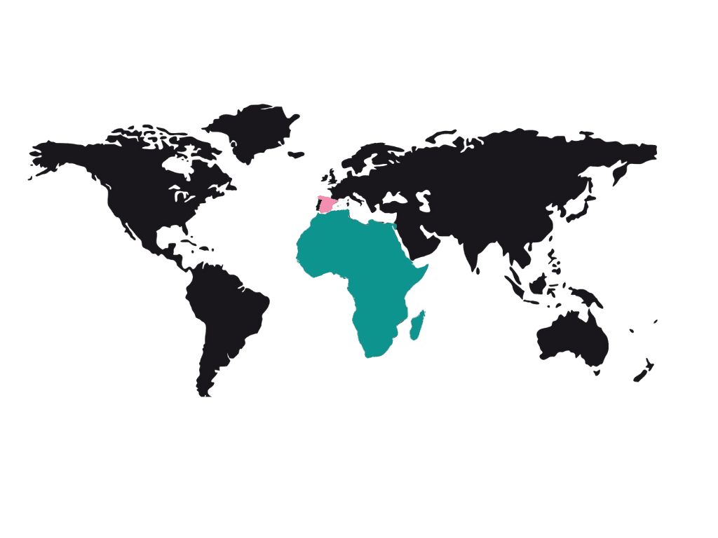
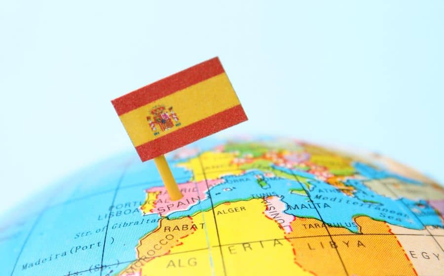
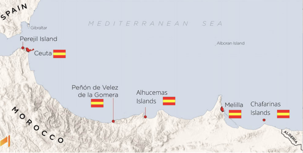
First, you should know that Spain is part of the European continent and Africa is a different continent. Spain is located in the southwest of Europe, but part of its territory is in the north of Africa. Spain occupies most of the Iberian Peninsula and is formed by two archipelagos, the Canary Islands and the Balearic Islands. BUT Spain also has two autonomous cities in North Africa, Ceuta, and Melilla, and three other areas as part of Africa: Peñón de Velez de la Gomera, Alhucemas Islands, and Chafarinas Islands.
2. Spanish territories in Africa 2022
- Ceuta
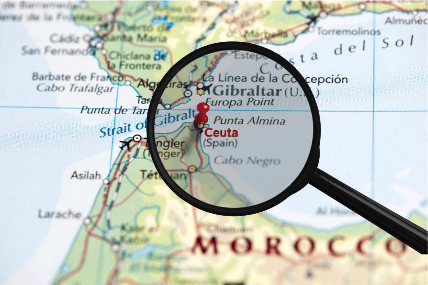
This Spanish autonomous city is located on the northern coast of Africa on the Strait of Gibraltar. Ceuta is bordered by Morocco and is located at the crossroads between the Mediterranean Sea and the Atlantic Ocean. It has an area of 18.5 km2. It’s the only Spanish territory in Africa, along with Melilla, which is permanently inhabited by civilian populations. It was a municipality that belonged to the province of Cadiz. Still, once its Statute of Autonomy was approved in March 1995, it became an autonomous city. Like Melilla and the Canary Islands, Ceuta was considered a free port before Spain became part of the European Union.
Its population is made up of Christians and Muslims, although there is a small minority of Jews and Hindus.
The official language is Spanish, but some can also speak Arabic.
- Melilla
Like Ceuta, Melilla is an autonomous city of Spain located in North Africa. We can locate it on the eastern side of the Cape of the Three Forks, bordering Morocco and facing the Mediterranean Sea.
It has an area of 12.3 km2. You should know that Melilla was part of the province of Malaga until March 1995 (like Ceuta), when the Statute of Autonomy of Melilla was approved.
The population is formed mainly by people of Iberian and Rifian extraction (Berber ethnic group originally from the Rif region of northeastern Morocco). In addition, we can find a part of the Jewish and Hindu populations. The official language is Spanish, and some of the population also speaks “tarifit.”
Melilla is considered a unique territory of the Member States within the European Union. All the movements between the European Union and Melilla must follow control and are subject to a series of rules specified in the agreement of Accession of Spain to the Schengen Convention.
- Peñón de Velez de la Gomera
It’s located in the north of Africa but it’s under the power of Spanish sovereignty. This fact has seemed to me very interesting. This region was originally a rocky island until, in 1930, an earthquake turned it into a peninsula, connecting it to the African continent. It’s located 126 km west of Melilla, and 117 km southeast of Ceuta; and has an area of 19,000 m2. Military groups of the Spanish Army permanently occupy the Peñón.The area separating Spain from Morocco by this rock is considered the minor border section in the world (85 meters long).
- Alhucemas Islands
Here we must consider that the Alhucemas Islands are a set of three islands belonging to the Spanish territory and are located on the Mediterranean coast of Morocco in the Bay of Alhucemas.
These islands are the Peñón of Alhucemas and the islands of Land and Sea (Islas de Tierra y Mar).
They are located about 155 kilometers east of the city of Ceuta and roughly 100 kilometers west of the city of Melilla.
The islands of Sea and Land can be located northwest of the rock at about 800-900 meters, respectively, and about 50 meters from the coast. Both islands are uninhabited and have no buildings.
However, on the Peñón of Alhucemas we can find a small Spanish population and some buildings such as a lighthouse, a church, a port, some houses, and some warehouses.
This territory is being claimed by Melilla but does not pose any danger to the Spanish sovereignty.
The Peñón of Alhucemas is also the mooring point for submarine cables linked to Ceuta, Melilla, and even the Iberian Peninsula. Military forces from Melilla are permanently guarding it.
- Chafarinas Islands
These islands form an archipelago in the Mediterranean Sea and are considered within Spanish territory. They are located off the coast of Morocco, about 3.5 km from it. This archipelago is formed by three islands, Congress Island, Island of Isabel II, and Island of King Francisco. They are under the protection of the National Hunting Refuge, so they can only be accessed by the Spanish military. They have a permit and are accompanied by guards and scientists from the Biological Station.
An essential fact that you should know is that the islands and rocks under Spanish power in North Africa are called “sovereignty places.” These sovereignty squares are the Alhucemas Islands, the Peñón Velez de la Gomera, and the Chafarinas Islands. As mentioned before, the Alhucemas and the Peñón are used mainly for military purposes, and the Chafarinas are protected under the National Hunting Refuge governed by the central state administration.
In addition to these five Spanish territories on the African continent, I would like to mention one more island under Spanish sovereignty but not considered within the African region.
- Alboran Island
This island is located 90 km off the coast of Spain and 65 km off the African coast. Alboran Island belongs administratively to the province of Almeria. The building that stands out the most is its lighthouse of the XIX century; it’s the most representative of the island since it doesn’t have much more infrastructure. Spain considers it a strategic area to control maritime traffic. Currently, it’s occupied by the military, dedicated to helping immigrants arriving on its shores aboard boats.
There’s also another island that I wanted to add because it plays an important role between Spain and Morocco.
- Perejil Island
I think it’s the easiest one to remember because of its name. This tiny island (500 metres long), is located in the Strait of Gibraltar, 200 meters from the African coast and 8 kilometers from Ceuta. Perejil Island remains uninhabited and its particularity lies in its legal status. This territory is disputed between Spain and Morocco but currently does not belong to either of them. But I’ll tell you about the conflict between the two countries later in this post.
3. Why does Spain have territories in Africa and since when?
Ceuta had belonged to the Kingdom of Spain since the 17th century, even before the Kingdom of Morocco existed. In 1415, Ceuta was one of the economic and strategic ports for the Islamic states, so for centuries, it was under the command of Berber and Arab dynasties. Although in the same year, Portugal conquered it. But many years later, in 1580, Spain and Portugal got together to form a joint dynasty. Ceuta also came under Spanish rule. But when these two countries separated in 1640, Spain was the one who kept Ceuta.
Melilla has belonged to Spain since the 15th century. It was conquered by the Crown of Castile in 1497 under the mandate of the Catholic Monarchs, just after the conquest of Granada.
The presence of Ceuta and Melilla in North Africa was a crucial factor in the expansion of Spain. Both territories allowed Spain to control the passage to the Mediterranean Sea through the Strait of Gibraltar.
Ceuta mainly served the flow of trade and people between the different territories. And Melilla was an excellent benefit for Spain as it had a port and a base to fight against the pirates.
Peñon de Velez de la Gomera has been part of Spain since 1508, with the arrival of a military group led by Pedro Navarro. General Navarro and his team confronted and defeated the pirates that occupied this area. Spain lost it in 1522 but finally recovered it in 1564. Currently, the Peñon is under a military regiment under the command of the maritime captaincy of Melilla.
Chafarinas Islands has belonged to Spain since January 6, 1848, with the arrival of General Serrano, who Queen Isabella II had sent. Before his arrival, this territory had not belonged to anyone.
Sultan Muley Abdullah ceded Alhucemas Islands to the Spanish Crown in 1560. The sultan ceded these islands to Philip II in exchange for protection against the attacks of the Ottoman Empire. But the islands were finally occupied in 1673 during the reign of Charles II. Since then, there has always been a small Spanish population, although those who currently inhabit the island are of military status.
4. Conflicts over Spain’s presence in Africa
As you may know, Ceuta and Melilla are the only territories in continental Africa that belong to the European Union. And this has been causing diplomatic disputes and migratory crises between Spain and Morocco for years. Ceuta and Melilla have been part of Spain for more than 500 years, but Morocco has always claimed them since its independence in 1956. Yet, Spain has never started any negotiations, nor does it seem to intend to do so. In fact, Spain refuses to negotiate since Ceuta and Melilla have been Spanish for more than five centuries and are part of the Spanish state. Moreover, the UN still considers that both cities belong to Spain. Its constant claims are due to Greater Morocco’s idea to have Ceuta, Melilla, and other areas of the North African territory. It also includes Western Sahara under its power.
Spain defends itself against these claims because some of these territories became Spanish long before Morocco became a state. Moreover, Ceuta and Melilla are not considered colonies but autonomous cities under the Spanish Constitution.
For Morocco, however, total control over Western Sahara is much more critical than getting its hands on Ceuta and Melilla.
There have also been clashes over the Spanish presence in the Peñon de Velez de la Gomera, the Peñón of Alhucemas, the Chafarinas, and the islet of Perejil.
Perejil island has been a headache for both nations, claiming equal sovereignty. It may not make sense to us, as we think of its tiny size and believe it isn’t worth it. But the key factor is its location; being situated in the Strait of Gibraltar makes it a strategic enclave for both territories.
That’s why, despite being a constant source of dispute between Spain and Morocco, they agreed that the islet would remain uninhabited without signs of sovereignty.
And so it was until 2002 when a group of Moroccan seafarers tried to invade the island, placing their country’s flag as a territorial claim. But their attempt to gain sovereignty over the country didn’t work, and the Spanish Armed Forces evicted them.
After this event, an agreement was reached that ended the conflict.
So both countries decided to recover the “status quo ante bellum” of the territory, agreeing that neither of the two could occupy it nor place any symbol referring to their sovereignty. This situation is still in place today.
5. The distance and what separates Spain from Africa
How far do you think Spain is from Africa? Any idea?
Well, the distance between the two continents is 14.4 km. Keep in mind that we are talking across the ocean.
And what separates Spain from Africa is the Strait of Gibraltar The Strait is located between the Alboran Sea and the Gulf of Cadiz. It’s the place where the Mediterranean Sea and the Atlantic Ocean meet; and where the separation of the European and African continents takes place.
And it has a depth of 300 to 900 meters!
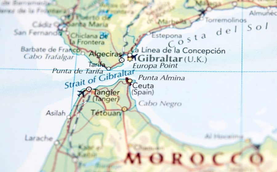
In the last centuries, the Strait of Gibraltar has been the site of many struggles, such as the battle of Trafalgar, the Muslim conquest of the Iberian Peninsula, and Gibraltar’s conquest essential role in the Second World War.
Nowadays, the Strait is considered one of the world’s most important and well-known shipping lanes due to its strategic position. It has an entrance to the Atlantic Ocean and the Mediterranean Sea, which allows it to communicate with the Near East and Asia through the Suez Canal at the same time. In addition, it represents that the Strait of Gibraltar is a crucial place for the passage of marine fauna and migratory birds.
Did you know all this?
After reading this post, I think your perspective on what occupies the Spanish territory has changed. Or am I wrong? My vision changed while I was writing it! It’s information that I think everyone should know because it’s something that is part of our history today. I hope this post has surprised you and that you have been able to expand your knowledge even more!


