45 Easy Fun Facts About Spain's Geography You Should Know
January 23, 2023
Win a FREE Trip to Spain!
Exciting Announcement! For the first time, we're thrilled to offer exclusive trips to the heart of Spain - an experience like no other. This isn't your typical tourist journey; it's a unique opportunity to immerse yourself in authentic Spanish culture, alongside real locals and our passionate team.
But there's more! Simply by requesting information about this amazing trip, you'll be entered into a special draw to win a Fully Paid Trip to Spain for Two. And that's not all - everyone who inquires will receive an exclusive bonus gift, valued at $500, available only now.
Ready to Discover the Real Spain?Click Here ↑ to Request Information & Enter the Draw!
With an area of just over 500,000 square kilometers, Spain is a beautiful transcontinental country located in southwestern Europe and North Africa.
It occupies most of the Iberian Peninsula and borders to the north with France and Andorra, to the west with Portugal, and Gibraltar to the south.
In this article, you will learn everything about the geography of Spain. I made it simple with facts and maps so you can understand everything immediately!
Also, I have other specific posts related to each topic. So, pay attention if you want to dig deep into some facts since I’ll share the links with you.
As we all know, Spain is mainly associated with the sea and beaches. Still, it is also one of the most mountainous countries in Europe. This makes the country very diverse in landscapes, such as beaches, mountains, plains, forests, lakes, and even deserts!
Get ready to discover the magnificent wonders that characterize this country. Let’s begin.
Table of Contents ▼ ▶
Oceans in Spain
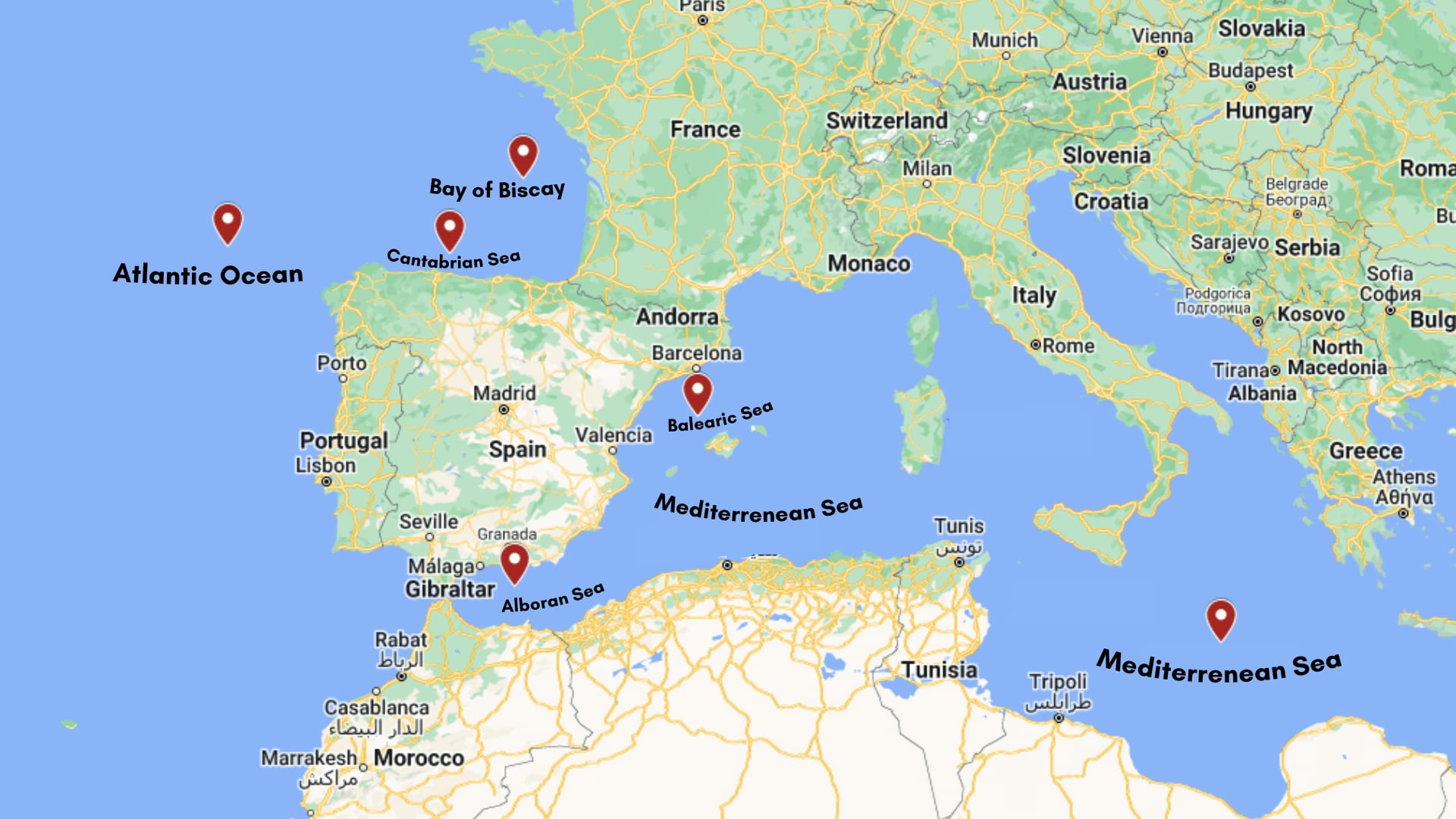
- The vast bodies of water surrounding Spain are the Atlantic Ocean, the Bay of Biscay, and the Mediterranean Sea. (Read more)
- Two sub-categories of the Atlantic ocean touch the coasts of Spain: the Mediterranean Sea, the Cantabrian Sea, and the Balearic Sea surrounding the islands. (Read more)
- Map of the oceans and seas that border Spain:

- The Mediterranean Sea is located between three continents, bordering Europe to the north, Africa to the south, and Asia to the east. The coastline of the Mediterranean Sea has a length of 46,000 km (28,600 miles). Its extensive coastline borders 22 countries on 3 continents: 11 in Europe, 5 in Asia, and 5 in Africa. (Read more)
- The Mediterranean Sea represents 1% of the surface area of the oceans, it is one of the largest in the world with 2,510,000 km2, but it isn’t the largest. Still, it would be among the five largest seas in the world, occupying the fourth position. (Read more)
- The Mediterranean Sea has about 8,750 islands in total, which are distributed along all its coasts. (Read more)
- The Mediterranean sea is salt water, with the highest salinity, with 38 grams of salt per liter. This high salinity is because the Mediterranean Sea loses three times more water through evaporation than the Freshwater it receives from the rivers that flow into it. (Read more)
- The Mediterranean Sea is one of the most important seas for human beings. It is shallow and has few currents, facilitating navigation, people’s movement, and transportation of goods. It’s strategic location has formed kingdoms and cities! (Read more)
Rivers in spain
- Spain has 528 rivers if we consider all rivers, tributaries, and subaffluents. But, considering rivers that do not discharge their waters into another river (those that are not tributaries), there are 83 rivers in Spain. (Read more)
- These are the 34 most important rivers in Spain, their length, and the slope they belong to. (Read more)
| Rivers | Lenght (in km) | Slope |
|---|---|---|
| 1. Tajo | 1007 | Atlantic slope |
| 2. Ebro | 910 | Mediterranean slope |
| 3. Duero | 895 | Atlantic slope |
| 4. Guadiana | 778 | Atlantic slope |
| 5. Guadalquivir | 657 | Atlantic slope |
| 6. Júcar | 498 | Mediterranean slope |
| 7. Segura | 325 | Mediterranean slope |
| 8. Miño | 310 | Atlantic slope |
| 9. Turia | 280 | Mediterranean slope |
| 10. Ter | 208 | Mediterranean slope |
| 11. Guadiaro | 183 | Mediterranean slope |
| 12. Llobregat | 170 | Mediterranean slope |
| 13. Guadalhorce | 166 | Mediterranean slope |
| 14. Guadalete | 157 | Atlantic slope |
| 15. Mijares | 156 | Mediterranean slope |
| 16. Nalón | 153 | Cantabrian slope |
| 17. Odiel | 150 | Atlantic slope |
| 18. Ulla | 132 | Atlantic slope |
| 19. Tambre | 125 | Atlantic slope |
| 20. Almanzora | 110 | Mediterranean slope |
| 21. Tinto | 100 | Atlantic slope |
| 22. Navia | 99 | Cantabrian slope |
| 23. Palancia | 85 | Mediterranean slope |
| 24. Vinalopó | 81 | Mediterranean slope |
| 25. Serpis | 75 | Mediterranean slope |
| 26. Nervión | 72 | Cantabrian slope |
| 27. Guadalfeo | 71 | Mediterranean slope |
| 28. Andarax | 67 | Mediterranean slope |
| 29. Bidasoa | 66 | Cantabrian slope |
| 30. Sella | 66 | Cantabrian slope |
| 31. Río Deva | 64 | Cantabrian slope |
| 32. Adra | 54.8 | Mediterranean slope |
| 33. Río Nansa | 53 | Cantabrian slope |
| 34. Guadalmedina | 47 | Mediterranean slope |
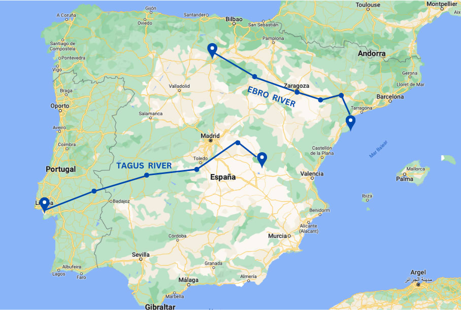
- The Tagus River is the longest in the Iberian Peninsula. However, it is located in one part of Spain (where it was born) and has another one in Portugal (where it flows in the Atlantic Ocean). (Read more)
- The Red River, or “Rio Tinto,” runs along the province of Huelva in Andalusia, rises in the Sierra de Padre Caro, and reaches the Huelva estuary, merging with the Odiel river. It is very particular since it is red! This phenomenon is due to the dissolution of minerals, oxides, and irons. (Read more)
- The length of the Tagus river is 1,007 kilometers, of which 816 kilometers are in Spanish territory, 46 kilometers constitute the border between Spain and Portugal, and the remaining 145 kilometers are part of Portugal. It has a surface area of 83,678 km², of which 67% is in Spanish territory and 33% is in the Portuguese part. (Read more)
- The Ebro River is the longest of Spain’s rivers (since its entire route is within Spain), with a length of 930 km. It has a surface area of about 85,000 km². But if we consider the entire Iberian Peninsula, although a part is in Spain and another in Portugal, it would be the Tagus River with 17,660 ft³/s. (Read more)
- The Ebro River is also the widest in Spain. It crosses seven autonomous communities: Cantabria, Castile, León, La Rioja, Basque Country, Navarra, Aragón, and Catalonia. (Read more)
- Tagus and Ebro river Map. The Tagus rises in Spain, crosses the entire Peninsula, and flows into Portugal in the Atlantic Ocean, while the Ebro makes its entire route within Spain to flow into the Mediterranean Sea. (Read more)

- The Guadalquivir is the only river in Spain with adequate current and conditions to sail. Today, it’s only navigable from the sea to Seville. Still, In the time of the Romans, it was navigable up to Córdoba. When the river was high enough, people could get to Andújar. (Read more)
- The Duoro River is the highest-flow river on the Iberian Peninsula. It begins in the province of Soria, specifically in Fuentes del Duero at 2,160 meters above sea level on the southern slope of the Urbión peak in the Duruelo de la Sierra, and flows all the way to the Atlantic Ocean through Portugal. Its wine route is more than 115 km long and 35 km wide, in which the cities of Valladolid, Burgos, Soria, and Segovia stand out. (Read more)
- The Community of Madrid has 13 major rivers: The Aulencia, Tajuña, Jarama, Henares, Guadarrama, Duratón, Algodor, Alberche, Manzanares, Lozoya, Guadalix, Perales, and Madarquillos River. (Read more)
- The most important rivers in Barcelona are the Besòs River, with a length of 18 km and a 3010 km² surface area of the basin; and the Llobregat River, which gives its name to the county, with 170 km and 4,948 km², respectively. (Read more)
These articles might be helpful in case you want to learn more specific information on the topics:
What is The Longest River in Spain? Experts Doubt between These 2!
All Northern Spain Rivers: The Beautiful Ebro + 29 More to Keep in Mind
Southern Spain River: Facts and Activities to Enjoy the Guadalquivir!
The 13 Best Rivers in Madrid to Enjoy a Different Outdoor Activity
The Best Rivers in Barcelona + 7 more in Catalonia!
The Beautiful Guadiana + 20 Rivers Between Spain & Portugal
All about River Duoro (Duero) and its great importance
Experience the Ebro River: 8 Interesting Facts, Best Spots, Beautiful Pictures and More!
The Tagus River: 2 Locations, Interesting Facts and The Best Spots
The Unique Rio Tinto in Spain: is the red river worth visiting?
Lakes in Spain
- The most important lakes in Spain are the Sanabria Lake, the Banyoles, the Pink Lake of Torrevieja, Rius Lake, Tort de Rius Lake, St. Mauritius Lake, Enol Lake, and the Embalse de Los Bermejales. (Read more)
| Lake | Depth | Surface |
|---|---|---|
| Sanabria Lake | 53 meters | 369 hectares |
| Banyoles Lake | 46 meters | 12 hectares |
| The Pink Lake of Torrevieja | 1,50 meters | 1.400 hectares |
| Rius Lake | 25 meters | 40 hectares |
| Tort de Rius Lake | Unkown | 13 hectares |
| St. Mauritius Lake | 40 meters | 114.119 hectares |
| Enol Lake | 25 meters | 80.000 m2 |
| Embalse de Los Bermejales | 100 meters | 5,62 km |
- The Covadonga Lakes are located in the National Park “Picos de Europa” and is the name given to three glacial lakes, one next to the other; Enol, Ercina, and Bricial. In the Lake is submerged an image of the Virgin of Covadonga. Every September, the 8 is taken out for a procession. (Read more)
- Lake Caicedo Yuso, or “Lago Arreo,” is the most essential natural body of water in the Basque Country. It isn’t the biggest, but the most relevant to scientists. The Lake is between Caicedo de Yuso and Arreo in the province of Álava. (Read more)
- The Gallocanta Lagoon is a natural reserve recognized as such in 2006. It is the most considerable salty body of water in the Iberian Peninsula.(Read more)
- The Sanabria Lake is the largest natural Lake in the Iberian Peninsula and one of the largest in Europe (the largest of glacial origin). It’s located in the community of Castile and Leon in the municipality of Galende, one of the most visited in Zamora. It is a lake of glacial origin, which makes its waters clear and clean, suitable for the best bathing. (Read more)
- The famous Retiro Park is located in the heart of Madrid. It was a gift from the Count-Duke of Olivares to Philip IV. Until 1868, these gardens were for the exclusive use and enjoyment of the monarchy, but in 1868 everything changed and became part of the City Council of Madrid; since then, all citizens have had access to the park. (Read more)
- The famous “El Pardo” belongs to the national patrimony of Spain. It was built in 1970, during the dictatorship of Francisco Franco. When the reserver was finally opened, something that no one expected happened… The valley was flooded, causing a strong impact on the ecological balance of Monte de El Pardo. (Read more)
To read more insights about these lakes, visit the following articles:
10 Interesting Facts About Spain Lakes (before you visit!)
The 35 Greatest and Largest Lakes in Spain! Ranked!
9 Top Rated Lakes in Madrid to Escape the City Life
The 5 Most Important Lakes in Northern Spain. Ranked!
The 4 Most Beautiful Lakes + 3 Natural Pools in Barcelona (or close to it)
Islands in Spain
- In the Mediterranean Sea, there is the Balearic archipelago, a popular destination visited by people worldwide, especially in the European summer. On the other hand, in the massive Atlantic Ocean, you will find the Spanish-African Canary Islands. Here, you will find all kinds of landscapes and the paradise of the Cíes with beaches that will make you feel like you are in the Caribbean. (Read more)
- The Spanish islands off the coast of Africa are the Canary Islands. It is an archipelago composed of 9 inhabited islands and 157 uninhabited islets, but only 8 islands and 5 islets are officially recognized. (Read more)
- The Canary Islands have two capitals. Because they are divided into two provinces, each province has a capital. These are shared between Las Palmas de Gran Canaria and Santa Cruz de Tenerife. (Read more)
- The Atlantic weather affects the country’s northern regions, such as Galicia, Cantabria, Asturias, and the Basque Country. If you ever travel to those regions, you should expect a lot of rain and a beautiful green landscape. They also have really cold winters and cool summers. (Read more)
- The Mediterranean weather affects most of the country, characterized by dry, hot temperatures. The regions dominated by this climate experience very, very hot summers and rainy, cold winters. (Read more)
- Spain is not in Africa. Spain is part of the European continent, and Africa is a different one. Spain is located in southwest Europe, but part of its territory is north of Africa. BUT Spain also has two autonomous cities in North Africa, Ceuta and Melilla, and three other areas as part of Africa: Peñón de Velez de la Gomera, Alhucemas Islands, and Chafarinas Islands. (Read more)
- Ibiza is located in the West part of Spain, about 80 kilometers off the coast of Valencia in the Mediterranean Sea. Ibiza is next to Mallorca, Menorca, and Formentera, also part of the Balearic Islands.
- Mallorca is the largest island of the Balearic Islands. It has 555 kilometers of coastline, so the list of beaches is endless! (Read more)
If you want to see related articles on these topics, read here:
The 15 Magical Islands in Spain to Visit Once in a Lifetime
The Canary Islands: 8 Beautiful Spanish Islands in Africa
Ibiza vs. Mallorca: Which One Is the Best? Which One Do I Choose?
Is Ibiza a Country? The Natural Paradise That Is Also a Celebrity Magnet
The Iberian Peninsula
- The four countries and one colony that occupy the Iberian Peninsula are Spain, Portugal, Andorra, Gibraltar, and France. (Read more)
- The Iberian countries share two crucial geographical features in the peninsula: the Pyrenees and the “Meseta Central” or Inner Plateau. (Read more)
- The only part of France considered part of the peninsula is the Oriental Pyrenees, right next to Catalonia. (Read more)
Mountains in Spain
- Spain’s mountainous system is numerous and occupies almost half of the national territory. It is formed by the following: (Read more)
- Betic mountain ranges.
- Cantabrian Mountain Range.
- Coastal-Catalan mountain range.
- Balearic Islands.
- Canary Islands.
- Galaico Massif.
- Central Plateau.
- Mountains of León.
- Mountains of Toledo.
- Pyrenees.
- Sierra Morena.
- Central System.
- Iberian System.
- Mount Teide is the highest Mountain in Spain, but not on the peninsula. It is located in Santa Cruz de Tenerife, the Canary Islands. These are the other ones:
| Mountains | Altitude (m) | Range | Province |
|---|---|---|---|
| Teide | 3,715 | Canary Islands | Santa Cruz de Tenerife |
| Mulhacén | 3,482 | Sierra Nevada | Granada |
| Aneto | 3,404 | Pyrenees | Huesca |
| Veleta | 3,394 | Sierra Nevada | Granada |
| Alcazaba | 3,371 | Sierra Nevada | Granada |
| Posets | 3,369 | Pyrenees | Huesca |
| Perdido | 3,355 | Pyrenees | Huesca |
| Cilindro de Marboré | 3,328 | Pyrenees | Huesca |
| Maladeta | 3,312 | Pyrenees | French/Spanish border |
| Perdguero | 3,222 | Pyrenees | Huesca |
- Tramonta mountain is the central mountain area of the Balearic Islands. With a length of 87 kilometers, it has approximately 54 peaks; the Puig Mayor the highest peak, with 1445 meters of height, becoming the highest mountain of all the Balearic Islands. It is a long and narrow mountain range painted with stone houses, terraced crops, cliffs, 3 large reservoirs, and hidden beaches. It was declared a World Heritage Site by UNESCO in 2011. (read more)
- The Pyrenees are the Spanish-French mountain range that separates the Iberian peninsula from France. These mountains are the tenth largest in Western Europe; before them, the Spanish Sierra Nevada, the Panibaetic System, and the Baetic System occupy positions seven, eight, and nine. (read more)
- Sierra Blanca, belonging to the Cordillera Penibética, is a mountainous range located in the province of Malaga in Andalusia. Between the municipalities of Istan, Ojén, Marbella, and Ronda, which is named for the whitish color of its limestone rock. It has an approximate extension of 6,500 hectares, and its highest peak is the peak of Lastonar: 1275 meters high. (read more)
- “Picos de Europa” was declared a Biosphere Reserve by UNESCO in 2003. It is a mountain range of limestone formations belonging to the Cantabrian mountain range and located in northern Spain (extending through Asturias, Leon, and Cantabria). (read more)
- The Sierra Nevada is a mountain range belonging to the Penibetic system, located between the Andalusian provinces of Granada and Almeria. And it is also a crucial ski resort with 126 kilometers of slopes. (read more)
9 Mountains Ranges in Spain for a Scenic Adventure
The Pyrenees in Spain and France: 12 Questions and Fun Facts
I hope you enjoyed reading this article. Let me know in the comments which fact surprised you the most, and if you’re ready to come to Spain, don’t hesitate and write us a message. We will be happy to hear from you!


